National Monuments, Surrounding TheWoodShedAZ!™ Immediate Area |
|
|
|
Walnut Creek Canyon National Monument
CONDITION: Paved National Park Road, off I-40
MILES: 23 one way from TheWoodShedAZ!™ DesertMasters™ Lodge
CONDITION: 4 miles of unpaved. 19 Miles paved.
ELEVATION: 5,850 feet
TREES: Juniper, Desert Pine and cactus
TIMING: All spring, summer and fall (don’t go for the tree colors, see this monument!)
CONTACT: Coconino National Forest, 928.526.0866 |
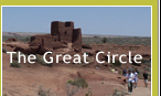
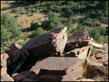
Wupatki National Monument
MILES: 6 unpaved. 5 paved. one way from TheWoodShedAZ!™ DesertMasters™ Lodge
ELEVATION: 5,200 feet
TREES: The lone Aspen or Cottonwood. In the Painted Desert
TIMING: Mid-September to mid-October (the lone Aspen in the Painted Desert but don’t go for the tree colors, see this monument!)
CONTACT: Coconino National Forrest, 928.526.0866 |
Sunset Crater National Monument
CONDITION: Paved
MILES: 18 miles one way. 6 miles of unpaved. 12 miles of paved.
ELEVATION: 6,500 feet
TREES: Juniper, Desert Ponderosa Pine
TIMING: All spring, summer and fall, (don’t go for the tree colors, see this monument!)
CONTACT: Coconino National Forest, 928.526.0866 |
San Francisco Peaks (Mt. Humphreys, Stratospheric Volcanic Landmark)
SnowBowl Ski Area FR 516 (Snowbowl Road) North from U.S. Route 180
CONDITION: Paved
MILES: 37 one way, from TheWoodShedAZ!™ DesertMasters™ Lodge
ELEVATION: 7,200 to 9,000 feet
TREES: Aspen (groves in top two miles)
TIMING: Mid-Sept. to mid-Oct.
CONTACT: Coconino National Forest, 928.526.0866 |
Grand Falls
CONDITION: Unpaved and paved, 12 miles unpaved. 4 miles paved.
MILES: 16 one way from TheWoodShedAZ!™ DesertMasters™ Lodge
ELEVATION: 5,200 feet
TREES: Desert willow
TIMING: Year round. Spring time is best, to see the falls (spring time waters running)
CONTACT: TheWoodShedAZ!, 877.237.6342 |
|
Distances are close estimates from TheWoodShedAZ!™ DesertMasters™Lodge location itself, 13 miles due East of the top of Mt. Elder in East Flagstaff. The lodge is located approximately six miles S.E. of Sunset Crater National Monument and 1 mile directly due west of Merriam Crater. |
*SR indicates a State Route and *FR indicates a Forest Service Road. For more detail regarding specific location of hiking trails, ask the Forest Service people or go to www.arizonahighways.com and click on ‘Fall Color Guide’. |
|